
Typhoon Fengshen: The 2025 Storm That Shaped Southeast Asia's Disaster Response
In the annals of Pacific typhoon history, Typhoon Fengshen stands out not for its brute force, but for the profound lessons it imparted about rainfall-driven disasters and regional cooperation. This Typhoon Fengshen, internationally designated as 2524 and known locally in the Philippines as "Ramil," was a classic example of how a storm of moderate intensity can unleash disproportionate humanitarian and economic challenges. Forming in mid-October 2025, the lifecycle of Typhoon Fengshen was a five-day drama that played out over the South China Sea, directly impacting millions and testing the disaster management frameworks of several nations. The story of Typhoon Fengshen is a compelling narrative of meteorology, human resilience, and the evolving understanding of tropical cyclone threats in a warming climate. This article delves deep into the journey of Typhoon Fengshen, from its genesis to its dissipation, analyzing its impacts and the critical responses it triggered.
The Genesis and Path of Typhoon Fengshen
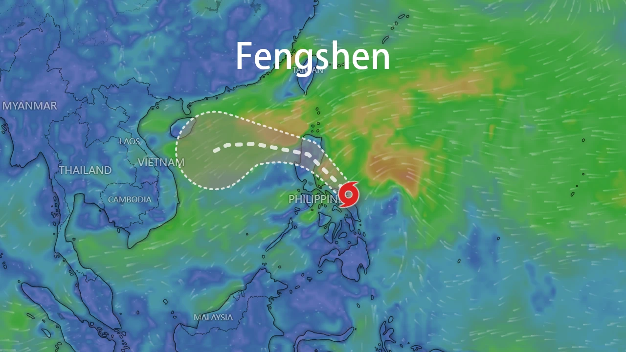
The birth of Typhoon Fengshen was a typical oceanic affair, nurtured by the warm waters of the western Pacific. On October 18, 2025, the system that would become Typhoon Fengshen coalesced into a tropical storm over the waters west of Luzon, Philippines. The initial formation of Typhoon Fengshen was driven by favorable conditions, including sea surface temperatures exceeding 28°C and weak vertical wind shear. However, the early development of Typhoon Fengshen was marked by structural fluctuations, briefly weakening to a tropical low before reorganizing and intensifying into a Severe Tropical Storm by October 20. The peak intensity of Typhoon Fengshen was recorded with maximum sustained winds of 20 m/s (about 72 km/h) and a central pressure of 996 hPa, firmly categorizing it below typhoon strength but still potent enough to be dangerous.
The trajectory of Typhoon Fengshen was a westward curve that skirted major landmasses while menacing coastal communities. Moving at a steady 20-25 km/h, the core of Typhoon Fengshen passed near the Paracel Islands (Xisha) on October 21, bringing it uncomfortably close to China's Hainan province. The path of Typhoon Fengshen then took a southwesterly turn, making its final landfall on October 22 along the central Vietnamese coast between Hue and Quang Ngai. This strategic, if unintentional, path meant that Typhoon Fengshen largely avoided a direct hit on the Chinese mainland, but its expansive outer bands ensured that its influence was felt far and wide. The entire journey of Typhoon Fengshen covered approximately 1,500 kilometers across the South China Sea, a relatively short but impactful lifespan that ended with its dissipation over Vietnam on October 23.
Intensity and Meteorological Characteristics of Fengshen
What made Typhoon Fengshen a subject of intense study was its failure to intensify dramatically despite being over energy-rich waters. The Typhoon Fengshen system was consistently inhibited by meteorological factors that prevented it from achieving a higher category. Key among these were the persistent intrusion of dry mid-level air and increasing vertical wind shear as it approached land. These factors stifled deep convection, leaving Typhoon Fengshen with an asymmetric structure and no well-defined eye. Satellite imagery of Typhoon Fengshen depicted a system with active but disorganized convection, a visual testament to the atmospheric battles it was losing.
Data from the Japan Meteorological Agency (JMA) and the Joint Typhoon Warning Center (JTWC) show a consistent narrative for Typhoon Fengshen: a storm that never quite lived up to its potential for wind-based destruction. The following table, compiled from official sources, summarizes the key stages in the life of Typhoon Fengshen:
| Date (UTC) | Position (Lat/Lon) | Central Pressure (hPa) | Max Wind (m/s) | Intensity Grade | Remarks |
|---|---|---|---|---|---|
| 2025-10-18 17:00 | 15.6°N, 119.6°E | 1000 | 20 | Tropical Storm | Formation near Philippines |
| 2025-10-20 17:00 | 18.2°N, 112.3°E | 996 | 20 | Severe Tropical Storm | Peak intensity near Hainan |
| 2025-10-21 08:00 | 17.3°N, 110.0°E | 998 | 18 | Severe Tropical Storm | Passing Paracel Islands |
| 2025-10-22 21:00 | 16.6°N, 108.7°E | 1002 | 18 | Tropical Storm | Approaching Vietnam coast |
| 2025-10-23 00:00 | 17.0°N, 108.0°E | 1006 | - | Tropical Low | Landfall in Central Vietnam, dissipation |
This table clearly illustrates the modest intensity of Typhoon Fengshen throughout its life. The storm's primary hazard was never its wind speed, a fact that would become tragically clear in the impact assessments.
Widespread Impacts and Humanitarian Toll of Fengshen
The legacy of Typhoon Fengshen is written in the floodwaters and landslides it triggered across the Philippines, Vietnam, and Southern China. Despite its classification, Typhoon Fengshen proved that rainfall is often the deadliest attribute of a tropical cyclone.
In the Philippines, Typhoon Fengshen (Ramil) was a brutal initiator of disaster. The storm made a series of four rapid-succession landfalls across Luzon on October 17-18, saturating the ground and leading to catastrophic flooding and landslides. The aftermath of Typhoon Fengshen in the Philippines included at least 8 confirmed deaths, with several others injured or missing. Torrential rains, exceeding 200 mm in many areas, caused rivers to overflow, isolating communities and forcing the evacuation of tens of thousands of people. Critical infrastructure was severely compromised; dozens of roads and bridges were damaged or rendered impassable, and maritime travel was halted, stranding thousands of passengers and goods. The economic cost from Typhoon Fengshen in the Philippines alone was estimated to be in the tens of millions of dollars.
For China, the main threat from Typhoon Fengshen came from its periphery. Hainan Island bore the brunt, experiencing heavy to torrential rainfall, with local accumulations surpassing 150 mm. While direct casualties were avoided, the storm disrupted daily life significantly. Flights were canceled, fishing fleets were ordered to port, and the threat of flooding was ever-present. The Chinese meteorological administration monitored Typhoon Fengshen closely, issuing yellow typhoon warnings and activating a Level IV emergency response to mitigate the storm's effects.
Vietnam faced a different kind of threat from Typhoon Fengshen. As the weakened system moved ashore, it acted as a moisture tap, funneling immense amounts of precipitation onto the central provinces. Rainfall forecasts for regions like Thua Thien-Hue and Quang Ngai reached a staggering 900 mm, raising alarms for devastating flash floods and landslides in the mountainous hinterlands. Coastal communities also braved storm surges and high waves. The proactive measures taken in response to Typhoon Fengshen likely prevented a higher death toll, showcasing a model of disaster preparedness.
Proactive Warning Systems and International Response to Fengshen
The response to Typhoon Fengshen highlighted a maturing regional approach to disaster risk reduction. From the moment Typhoon Fengshen was identified, a multi-national warning machinery swung into action.
The Philippines' PAGASA issued regular bulletins and storm signals, keeping the population informed about the movements of Typhoon Fengshen. Their efforts were complemented by the National Disaster Risk Reduction and Management Council (NDRRMC), which coordinated evacuations and post-storm damage assessments. China's Central Meteorological Office maintained a continuous watch on Typhoon Fengshen, providing forecasts that enabled provincial governments in Hainan and Guangdong to take precautionary measures. Vietnam's response to Typhoon Fengshen was notably proactive. Prime Minister Pham Minh Chinh himself issued directives, urging the mobilization of all resources. A remarkable feat was the coordinated pre-emptive release of water from 121 reservoirs to create flood buffer capacity, a direct lesson applied in anticipation of Typhoon Fengshen' deluge. Furthermore, an efficient SMS early warning system blasted alerts to over 6.8 million citizens in the storm's path.
Internationally, the AHA Centre provided critical updates and coordination support, while global meteorological organizations like the WMO Beijing World Meteorological Centre tracked the journey of Typhoon Fengshen in real-time, sharing data that benefitted all affected countries. The event demonstrated that while a storm like Typhoon Fengshen respects no borders, the response to it can be a united, cross-border endeavor.
Conclusion: The Enduring Lessons from Typhoon Fengshen
Typhoon Fengshen may not have been the strongest storm of the 2025 season, but its impact was profound. The experience with Typhoon Fengshen reinforces the critical need to look beyond the Saffir-Simpson scale and prioritize rainfall and flood potential in tropical cyclone warnings. The storm underscored the effectiveness of proactive, pre-emptive measures, as seen in Vietnam's reservoir management, versus reactive disaster relief. As climate change continues to influence weather patterns, the story of Typhoon Fengshen will serve as a crucial reference point for improving predictive models, refining evacuation protocols, and strengthening regional cooperation. The memory of Typhoon Fengshen is a sobering reminder that in the realm of natural disasters, sometimes the most significant threats come not from the wind's roar, but from the rain's relentless fall.