
Hurricane Narda: The 2025 Pacific Storm That Captivated Forecasters
In the bustling 2025 Eastern Pacific hurricane season, one name stood out for its dramatic intensity and far-reaching ocean swells: Hurricane Narda. This powerful cyclone carved a path through the open ocean in late September, never making direct landfall yet commanding attention from meteorologists and coastal communities from Mexico to Southern California. The story of Narda is one of rapid intensification, careful tracking, and indirect impacts that demonstrated how even distant storms can create dangerous conditions hundreds of miles from their center.
The Birth and Journey of a Powerful Cyclone
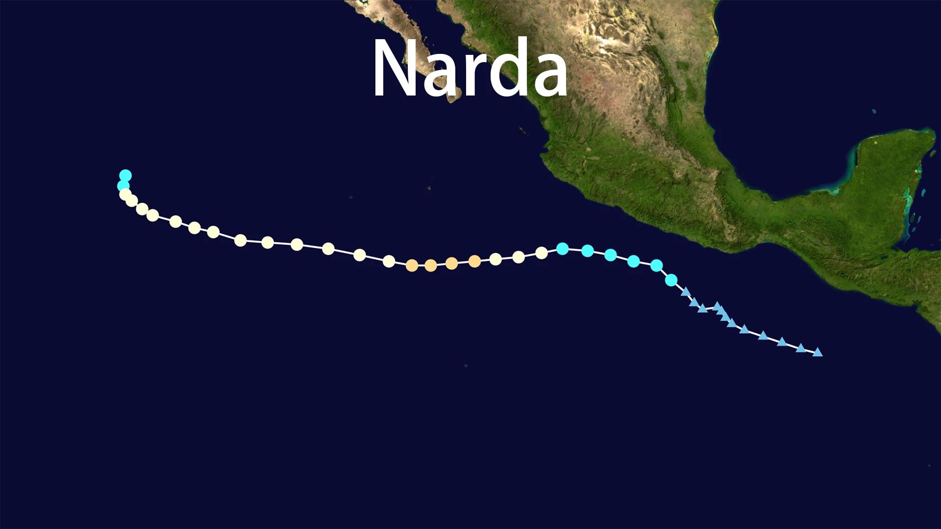
The meteorological history of Hurricane Narda began modestly enough with a trough of low pressure producing disorganized showers off southern Mexico around September 18, 2025. Over the following days, this system gradually organized until it achieved sufficient structure to be classified as Tropical Storm Narda on September 21, located approximately 240 miles south-southeast of Zihuatanejo, Guerrero. The newly formed Narda initially battled moderate wind shear but found favorable conditions to strengthen as it turned westward, influenced by a building subtropical ridge to its north.
The transformation of Narda from tropical storm to hurricane was remarkably swift. By September 23, just two days after formation, the system had intensified into a Category 1 hurricane with sustained winds reaching 75 mph. But Narda wasn't finished yet. The storm continued gathering strength through the following day, achieving its peak intensity as a Category 2 hurricane on September 24 with maximum sustained winds of 105 mph and a central pressure of 970 mbar. At this powerful stage, hurricane-force winds extended 30 miles from the center, with tropical-storm-force winds reaching outward 90 miles.
Tracking Narda's Path and Intensity Fluctuations
The movement of Hurricane Narda followed a characteristic pattern for Eastern Pacific systems, initially moving westward before taking a west-northwestward track that kept the storm safely away from major population centers. The steering currents that guided Narda ensured the cyclone remained over open waters throughout its lifecycle, paralleling the Mexican coastline but never making direct landfall. This path proved fortunate for coastal communities, though the storm's immense size still generated significant impacts.
As Narda encountered less favorable conditions including increasing wind shear, drier air, and cooler waters, gradual weakening began around September 25. The mighty Hurricane Narda was downgraded to a tropical storm on September 27 as winds dropped to around 50 mph, with the system's movement shifting northward at about 6-8 mph in its final days. The once-powerful Narda degenerated into a post-tropical cyclone by September 28, with the remnant low fully dissipating by the following day around 20.9°N 125.1°W, ending the nine-day lifecycle of this notable storm.
Impacts and Coastal Effects From the Distant Storm
Although Hurricane Narda remained offshore throughout its existence, the storm's influence extended far beyond its official wind radii. Mexican authorities issued alerts for heavy rains and dangerous waves along western coastal states, with forecasts predicting rainfall of 75-150 mm within 24 hours for Guerrero, Michoacán, and Colima. Wind gusts up to 170 km/h and significant waves of 2.5-3.5 meters raised concerns about potential flooding, landslides, and rising river levels, though comprehensive damage reports suggested impacts were manageable with proper precautions.
The most dramatic effects from Hurricane Narda manifested in Southern California, where powerful swells generated by the distant storm created hazardous surf conditions beginning September 28. The energy radiating from Narda transformed Southern California beaches with waves reaching 6-10 feet, with sets up to 10 feet at south-facing beaches like Newport Beach and The Wedge. These powerful waves, combined with strong longshore and rip currents, created dangerous conditions that prompted lifeguards to conduct dozens of rescues—45 in Newport Beach alone on September 28, plus 265 preventive actions. The legacy of Narda served as a powerful reminder that even storms that never touch land can create dangerous marine conditions through their energy propagation across the ocean.
Meteorological Context and Historical Significance
Within the broader context of the 2025 Eastern Pacific hurricane season, Hurricane Narda represented the 14th named storm and 8th hurricane in a basin known for producing powerful cyclones. The journey of Narda from formation to dissipation followed a classic pattern for Eastern Pacific systems that develop off the Mexican coast and curve westward into open waters. What made Narda notable wasn't its track but its intensity—reaching Category 2 status placed it among the stronger systems of the season, though far from record-breaking.
The dissipation of Hurricane Narda on September 29, 2025, marked the end of a storm that exemplified both the power and unpredictability of tropical systems. While Narda caused no direct casualties and limited damage thanks to its offshore track, the storm demonstrated how even distant cyclones require vigilance from coastal communities and emergency managers. The story of Narda continues to inform meteorological understanding of how Eastern Pacific hurricanes generate far-reaching impacts through swell propagation, ensuring this storm remains a subject of study and discussion among weather enthusiasts and professionals alike.