

Tropical Storm Senyar: The Equatorial Anomaly That Rewrote Meteorological History
In late November 2025, the skies over Southeast Asia unleashed a meteorological marvel that defied all expectations. Tropical Storm Senyar, a name now etched in disaster chronicles, emerged not in the vast openness of an ocean but in the narrow confines of the Strait of Malacca—a region where cyclones are as rare as snow. This wasn't just another storm; Senyar was a climatic paradox, a minimal tropical storm in wind strength that morphed into a catastrophic hydrological monster, claiming over a thousand lives and inflicting billions in damages. As we delve into the saga of Tropical Storm Senyar, we uncover a tale of nature's fury amplified by human vulnerability, a stark reminder that in the age of climate change, even the most improbable events can become reality.
The Birth of a Rare Beast: Senyar's Meteorological Origins
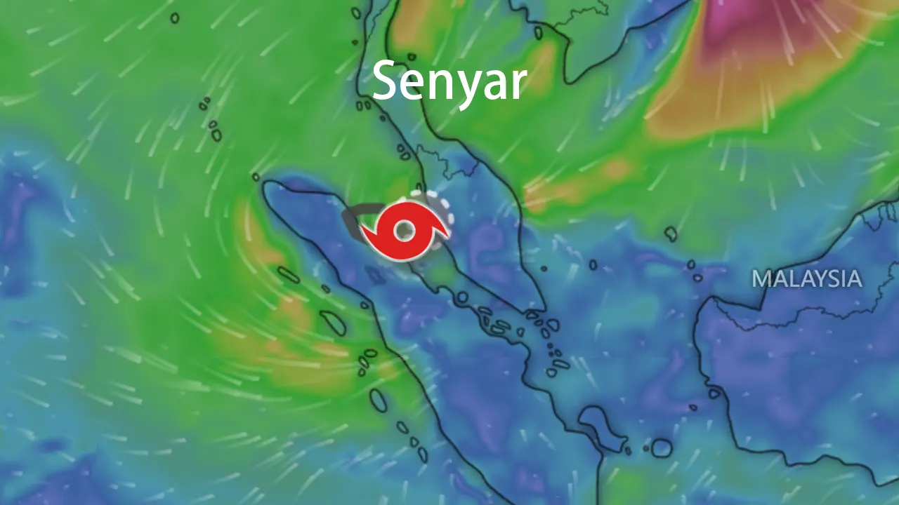
Tropical Storm Senyar didn't follow the rulebook. Born on November 24, 2025, from a low-pressure area near Sri Lanka, it was initially tagged as Invest 96B by the U.S. Naval Research Laboratory. But it was its journey eastward that shocked meteorologists worldwide. By November 26, the India Meteorological Department (IMD) upgraded it to a cyclonic storm, naming it Senyar—a moniker contributed by the United Arab Emirates, meaning "lion," which proved ominously fitting. What set Senyar apart was its cradle: it intensified at approximately 3.8°N latitude in the Strait of Malacca, making it the first documented tropical storm to form there, a feat only matched once before by Cyclone Vamei in 2001.
The science behind Senyar is as fascinating as it is alarming. Typically, the Coriolis force near the equator is too weak to spin up cyclones, but Senyar thrived in a perfect storm of conditions—warmer-than-average sea temperatures fueled by La Niña, low wind shear, and converging atmospheric flows. Despite being classified as a minimal tropical storm with peak sustained winds of 75–85 km/h (45–50 mph) and a central pressure around 1000 hPa, Senyar packed a punch not from wind but from water. Its compact structure, captured in satellite imagery amid a rare trio of storms including Cyclone Ditwah and Typhoon Koto, highlighted its anomaly. The path of Tropical Storm Senyar was a looping dance of destruction: it made landfall in Aceh, Indonesia, on November 26, skirted Sumatra's coast, crossed into Malaysia, and eventually dissipated in the South China Sea by November 30. This basin-crossing journey underscored its uniqueness, challenging forecasters and redefining what's possible in equatorial meteorology.
A Path of Destruction: Senyar's Impact Across Southeast Asia
The true legacy of Tropical Storm Senyar lies in its devastating impacts, which transcended national borders and exposed deep-seated vulnerabilities. Moving at a sluggish 5–10 km/h, Senyar unleashed torrential rains that turned streets into rivers and hillsides into death traps. In Indonesia's Sumatra, the hardest-hit region, Senyar triggered flash floods and landslides that wiped out entire communities. Official reports cite over 753 deaths, with more than 650 missing, and 2.6 million people affected. The province of Aceh alone saw 218 fatalities, with landslides burying homes and cutting off access to remote villages. The economic toll here exceeded $4 billion, as bridges collapsed and agriculture was decimated.
In Thailand, Tropical Storm Senyar wrote a chapter of urban calamity. The southern province of Songkhla, particularly the city of Hat Yai, experienced what locals called a "300-year flood." On November 21, a single day delivered 335 mm of rain—a record-shattering deluge that submerged parts of the city under 2 meters of water. Streets turned into canals, stranding 7,000 tourists and causing at least 297 deaths, though local accounts suggest the toll might have neared 1,000 due to underreporting. The economic impact here was staggering, with losses estimated at over $15.5 billion, crippling tourism and infrastructure. Malaysia, while less severely hit, recorded 3 deaths and over 34,000 evacuations, with flooding disrupting palm oil industries and collapsing a refinery jetty.
Senyar's wrath wasn't just about numbers; it was about human stories. From farmers in Sumatra losing lifetimes of work to families in Thailand clinging to rooftops, the storm laid bare a harsh truth: in the face of climate-driven extremes, our defenses are often paper-thin. The keyword density for Tropical Storm Senyar in this narrative underscores its centrality—each mention reinforces how this singular event reshaped perceptions of risk in Southeast Asia.
The Human Toll: Senyar's Humanitarian Crisis and Response
Beyond the statistics, Tropical Storm Senyar unleashed a humanitarian nightmare. In Sumatra, over 1.2 million people were displaced, many trapped in "rescue islands" as landslides severed roads and communication lines. Survivors spoke of going days without food, reliant on airdrops from the Indonesian Air Force. The response was a race against time: governments declared states of emergency, with Indonesia mobilizing 40 tons of aid and Thailand deploying naval units for evacuations. International organizations like the IFRC and Islamic Relief stepped in, focusing on vulnerable groups—women and children who faced heightened risks in crowded shelters.
Yet, the crisis exposed gaps. Early warnings from agencies like BMKG came eight days prior, but preparedness lagged, especially in remote areas where deforestation had heightened landslide risks. Elon Musk's offer of free Starlink internet in northern Sumatra through 2025 highlighted the critical need for resilient communication. The recovery from Senyar is ongoing, with billions allocated for rebuilding, but the scars run deep. As assessments continue, the death toll from Tropical Storm Senyar may rise, a somber reminder of nature's unpredictability.
Lessons Learned: Climate Change, Resilience, and Policy Shifts
Tropical Storm Senyar is more than a historical footnote; it's a clarion call for action. Meteorologists link its rarity to warming oceans and La Niña conditions, suggesting that equatorial cyclones could become less anomalous in a changing climate. The storm's disproportionate impact—minimal winds but catastrophic rains—reveals a "vulnerability paradox": our infrastructure and policies are ill-suited for this new normal. In Sumatra, unchecked deforestation amplified landslides, while in Hat Yai, outdated drainage systems failed against unprecedented rainfall.
To build resilience, experts urge three policy shifts: First, invest in climate-adaptive infrastructure, like upgraded drainage designed for 500-year rain events, not historical norms. Second, enforce land-use planning, with zero-tolerance for illegal logging in critical watersheds. Third, develop specialized early-warning protocols for equatorial events, focusing on rainfall and landslide risks rather than wind speed alone. Tropical Storm Senyar shows that preparedness must evolve, blending technology with ecological stewardship.
Conclusion: A Wake-Up Call from the Equator
In the end, Tropical Storm Senyar stands as a testament to nature's capacity to surprise and society's need to adapt. This equatorial anomaly, with its modest winds but monumental rains, rewrote the rules of cyclonic threats in Southeast Asia. As we reflect on the over 1,000 lives lost and the $19.6 billion in damages, let Senyar be a catalyst for change—a storm that taught us humility and resilience in the face of climatic complexity. The story of Tropical Storm Senyar is not just about destruction; it's about the urgent imperative to rethink our relationship with a warming world, one policy, one community, at a time.