
Cyclone Fina: Australia's Early-Season Tempest of 2025
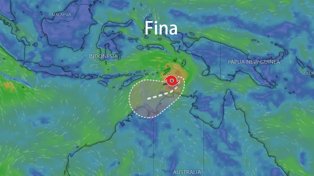
In mid-November 2025, while the Southern Hemisphere's cyclone season was just stirring, the waters north of Australia brewed a surprise. What began as an unassuming tropical low over the Timor Sea rapidly transformed into Severe Tropical Cyclone Fina, delivering a potent and early blow to the nation's Top End. This storm defied typical seasonal patterns, becoming the most intense November cyclone to threaten Australian coasts in two decades. The story of Cyclone Fina is one of rapid intensification fueled by anomalous climate drivers, a test of urban preparedness for Darwin, and a stark reminder of the vulnerabilities in remote coastal regions.
Genesis in the Timor Sea
The origins of Cyclone Fina can be traced to November 14, 2025, when a persistent area of low pressure, designated as 02U by the Australian Bureau of Meteorology (BOM), formed over the warm waters of the Timor Sea. Initially drifting eastwards, the system found itself in a conducive environment. A maturing La Niña pattern, characterized by a -0.93°C anomaly in the Niño3.4 sea surface temperature index, was setting the stage across the Pacific. More locally, ocean temperatures around northern Australia were significantly above average, with parts of the Coral Sea recording anomalies exceeding +1.2°C. This pool of warm water provided the essential fuel for tropical systems.
By November 18, the system had organized sufficiently to be named Tropical Cyclone Fina. Early forecasts predicted a moderate-strength system, but Fina had other plans. Feeding on the exceptionally warm seas, it began a period of steady intensification. On November 21, it made its first landfall on the remote Coburg Peninsula as a Category 2 system, but its journey was far from over. The core of Cyclone Fina then moved over the Van Diemen Gulf, a body of water known to act as an incubator for cyclones due to its heat content.
Rapid Intensification and Coastal Threat
The traverse over the Van Diemen Gulf marked a critical turning point for Cyclone Fina. Freed from the friction of land and over bath-warm water, the storm underwent rapid intensification. In a matter of hours, it exploded into a Severe Tropical Cyclone, reaching Category 3 status. By the evening of November 22, Cyclone Fina was bearing down on the Darwin region with sustained winds of 150 km/h and destructive gusts reaching 205 km/h.
Darwin, a city familiar with cyclone threats, activated its well-rehearsed emergency protocols. The BOM issued urgent warnings, advising residents from Darwin to Cape Hotham to "take shelter now." A Code Brown was declared at the Royal Darwin Hospital, the airport and major supermarkets shut down, and evacuation centers opened. The city effectively went into lockdown as the core of Severe Tropical Cyclone Fina passed perilously close. The sound of howling winds and falling trees filled the night, and power was cut to approximately 19,000 homes and businesses. While the city avoided a direct eye-wall strike, the impacts were severe, with widespread tree damage, localized flooding, and reports of structural damage, including a section of the hospital's roof.
Peak Fury and Final Landfall
After skirting Darwin, Cyclone Fina moved westward over the Joseph Bonaparte Gulf, where it achieved its peak intensity. Early on November 24, the system was upgraded to a Category 4 Severe Tropical Cyclone. Satellite imagery revealed a distinct eye as the storm packed maximum 10-minute sustained winds of 185 km/h, with peak gusts estimated near a terrifying 260 km/h.
This formidable system then set its sights on the sparsely populated Kimberley coast of Western Australia. On the night of November 24, Cyclone Fina made its final landfall near the Berkeley River mouth. It crossed the coast as a Category 3 system, but its winds remained devastating. The luxury and isolated Berkeley River Lodge bore the brunt, suffering "significant" and "devastating" damage from the extreme winds, a testament to the storm's ferocity even as it began to weaken over land.
The following table summarizes the key intensity changes of Cyclone Fina:
| Date (2025) | Stage / Category (Aus.) | Max Sustained Winds (10-min avg) | Key Event |
|---|---|---|---|
| Nov 14 | Tropical Low (02U) | < 65 km/h | Formation in the Timor Sea. |
| Nov 18 | Category 1 | 65-90 km/h | Named Cyclone Fina. |
| Nov 21 | Category 2 | ~95 km/h | First landfall, Coburg Peninsula. |
| Nov 22 | Severe Category 3 | 150 km/h | Rapid intensification; threat to Darwin. |
| Nov 24 | Severe Category 4 (Peak) | 185 km/h | Peak intensity over water. |
| Nov 24 | Severe Category 3 | ~140 km/h | Final landfall, Kimberley coast. |
| Nov 26 | Ex-Tropical Low | - | Dissipated inland. |
The Aftermath: Rain, Floods, and Recovery
As the wind threat subsided, a second major hazard emerged: torrential rainfall. The slow-moving nature of Cyclone Fina's remnant low allowed it to dump extraordinary amounts of rain across the Kimberley. Wyndham Aero recorded a staggering 147.2 mm in just 24 hours, setting a new November daily record for the site. The weekly total reached 222.8 mm, causing major flooding in river systems and isolating communities.
The socioeconomic impacts of Cyclone Fina were multifaceted. In Darwin, the recovery focused on restoring power, clearing an estimated 170,000 tonnes of green waste from fallen trees, and repairing public infrastructure. The financial cost, particularly for under-insured or uninsured remote assets like the Berkeley River Lodge, was severe. Notably, the effective early warnings and community compliance resulted in no reported fatalities or serious injuries, a major success for disaster management.
The event prompted discussions on climate linkages. The concurrent La Niña and record-warm sea temperatures were identified as key drivers for Fina's early-season intensity. This anomaly is captured in the climatic conditions preceding the storm:
| Climate Indicator | Value (Period) | Significance for Cyclone Fina |
|---|---|---|
| Niño3.4 SST Anomaly | -0.93°C (Nov 23) | Confirmed active La Niña, favoring cyclone activity near Australia. |
| 90-Day Southern Oscillation Index | +8.5 (to Nov 23) | Strong atmospheric signal of sustained La Niña conditions. |
| Regional SST Anomaly | Up to +1.2°C (Coral Sea) | Provided extreme oceanic heat content for intensification. |
Conclusion: Lessons from an Early Blow
Severe Tropical Cyclone Fina served as an abrupt commencement to the 2025-26 Australian cyclone season. It demonstrated how a confluence of large-scale climate patterns can produce significant threats outside the traditional peak season. The storm highlighted exemplary urban preparedness in Darwin but also underscored the persistent vulnerability of isolated infrastructure in remote northern Australia.
The legacy of Cyclone Fina is a clear warning about the expanding window of cyclone risks. It emphasizes the need for preparedness calendars to be guided by dynamic climate indicators rather than fixed dates and reinforces the ongoing necessity to build resilience from major cities to the most secluded outposts. As ocean temperatures continue to rise, the potential for more storms like Fina—intense, early, and unpredictable—only increases.